Quick answer Drone land photography lets buyers see a plot's shape, its access road and its surroundings in a single image. The shots to get are a top-down view to show the plot's shape, an oblique view showing the road and terrain, a wide shot showing the location relative to main roads or communities, and a short video flying in from the road to the plot. Drone images only show boundaries approximately; they are not a survey. Before every flight, the team checks no-fly zones and gets the landowner's permission.
Empty land is hard to make interesting from the ground—wherever you stand, all you see is grass and trees. Buyers scrolling past a listing can't tell how the plot sits, which side faces the road, or what is nearby. This article draws on ORBITCINE's real land shoots to explain which shots to take, what to prepare before flight day, and how far drone images can help with boundaries—for landowners and agents about to list land for sale.
Have land you want to list for sale?
Send the coordinates or sub-district name and the team will check no-fly zones first, free of charge, then send you a quote within one day.
How drone land photography helps sell
An aerial image answers a buyer's first questions in one frame: where the plot is, what it borders, and how big it is compared with its surroundings. What would take several sentences to explain, one image covers.
- See the plot's shape and road frontage Square plots, long deep plots or narrow-frontage plots—buyers see it instantly without opening the title deed.
- See the access and road conditions Paved road, laterite road, or access through someone else's land—buyers want to know before booking a viewing.
- See the location and surroundings Distance to main roads, communities, water sources or mountains helps people unfamiliar with the area picture it.
- Fewer repeat site visits Buyers who live far away can make an initial decision before traveling, so in-person viewings are left to genuinely interested buyers.
The same set of images works across channels: property listing websites, land-trading pages and groups on Facebook, and forwarding on LINE to buyers who get in touch.
Drone land photography: which shots do you need?
A complete listing set should include at least these 5 types, each answering a different buyer question.
| Shot | What it shows | Where to use it |
|---|---|---|
| Top-down view | Plot shape, approximate boundaries and road frontage | Main listing image, and for drawing approximate boundary lines |
| Oblique view | Terrain, trees, ground elevation and the access road | Images 2–3 of the listing |
| Wide shot | Location relative to main roads, communities or water | Explaining the journey and the atmosphere around the plot |
| Video flying from the road to the plot | The actual access route and an overview of the whole plot | Social media posts, and for buyers who are far away |
| Plot highlight shots | Water sources, views or existing structures | Closing image of the listing |
Timing matters too: late-morning and late-afternoon light give the land very different depth. The team picks the time when boundaries and ground texture are clearest, and avoids days with rain, strong wind or haze that blurs the image.
How well can drone land photography show boundaries?
Drone images show the plot's shape clearly, but boundary lines drawn on an image are only approximate—they are not a survey. If you draw boundary lines on a listing image, label them as approximate and ask buyers to check against the title deed. Legally accurate boundaries require a survey by the Department of Lands or a licensed surveyor.
Before the shoot, landowners can check the plot's location using LandsMaps, the Department of Lands' land parcel search system (searchable by title deed number), then send the coordinates to the team for flight planning. Another big help is tying brightly colored cloth or flags to the boundary markers at each corner before flight day, so the corners stand out in aerial images.
Drone land photography: what to prepare
- Coordinates or a map link for the plot Used to check no-fly zones and plan camera angles in advance.
- The landowner's consent If you are an agent, have the owner confirm permission to fly and to use the images in the listing.
- Markers on the boundary posts Brightly colored cloth or flags visible from above.
- A clear enough access way If you can cut the grass along the access route or boundary, the images become much easier to read.
- A list of selling points Such as main roads, water sources, views or nearby communities, so all shots can be planned within one flight.
- A guide on site Helps open up the area and point out the plot corners. If that's not convenient, send the details in advance via LINE.
Flight rules you need to know
Most land jobs are outside the city, but every CAAT flight condition still applies—for example, flying no higher than 90 meters, keeping the drone within visual line of sight, flying only between sunrise and sunset, keeping distance from uninvolved people, vehicles and buildings, and not flying within 9 kilometers of an airport or in restricted areas unless authorized. Land near borders or military areas therefore always needs a coordinate check first. For a quick look, see Drone no-fly zone map by province and 4 types of drone no-fly zones
Another often-overlooked issue is neighbors' privacy. Aerial images may capture adjacent houses or local people; the team frames shots so they don't intrude into other people's homes and avoids capturing identifiable faces of uninvolved people.
Real example: land photography in Phetchaburi
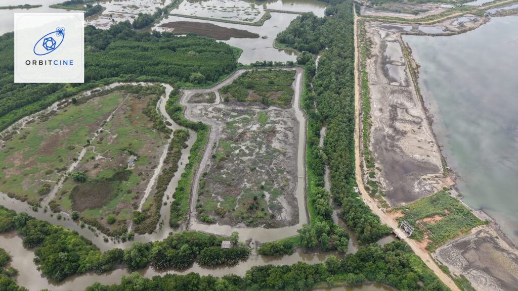
For this job, the landowner wanted to see the entire plot in a single image. The team checked no-fly zones before going on site, chose light that showed boundaries and ground texture clearly, then captured top-down, oblique and wide shots. Deliverables were high-resolution RAW stills plus aerial video, with embedded location data removed from every file before delivery. See the details at Aerial Land Photography – Phetchaburi and watch the 45-second sample clip on the page Real estate drone photography
Frequently asked questions
Drone land photography: how long does one plot take?
Flight time for capturing images is usually a few dozen minutes per plot, but total time on site depends on the area size, the number of angles needed and the weather that day. The team will estimate this before accepting the job.
Do I need the original title deed?
No, but you should send the coordinates or a rough map of the plot first, so the team can check no-fly zones and plan flight angles to match the area you want.
Can drone images replace a land survey?
No. Images only show the plot's shape and approximate boundaries. For legally accurate boundaries, you need a survey by the Department of Lands or a licensed surveyor.
Can you fly if the land is near an airport or military area?
It depends on the exact coordinates. Some areas can't be flown at all; others can be flown with advance permission. Send the coordinates or sub-district name for the team to check first, free of charge.
What files do I get, and when?
You get high-resolution stills and aerial video as agreed; full-resolution RAW files are available on request. On average, files are delivered within 3–7 business days after the shoot, depending on the amount of editing.
Will our land information be published?
We never publish title documents, precise plot locations or landowners' names in public media. Work shown in our portfolio is identified only at the province level, and location data is removed from every file before delivery.
Can you shoot if the land is still overgrown?
Yes, but boundaries will be harder to read in the images. If you can cut the grass along the access route or boundary before the shoot, the images will be much clearer. If not, the team will focus on oblique and wide shots that show the location instead.
Can an agent book several plots in one day?
Yes, if the plots are on the same route. Send the coordinates of all plots together; the team will check permission requirements for each location and plan the most time-efficient route.
Drone land photography: how is it priced?
It depends on the area size, number of plots, travel distance and the files you need. See the factors that affect pricing in How much does drone photography cost? or send your job details to get a free quote.
Summary
Aerial images turn empty land into something buyers understand in seconds. The shots to get are top-down, oblique, wide and a short video from the road to the plot. Prepare the coordinates, the owner's consent and markers on the boundary posts, then choose a team that checks no-fly zones and strips location data from files every time. One set of images works for listings, social media and buyers who are far away.
Send your land coordinates for the team to check first
The ORBITCINE team checks no-fly zones, plans a shot set that fits your listing, and sends a quote within one day.
Read next: Drone photography for real estate: houses, land and projects · How much does drone photography cost? What to check before you hire a team · Drone photography in Phetchaburi and Cha-am
Sources: CAAT — Drone in-flight conditions · Department of Lands — LandsMaps land parcel search system
- Civil Aviation Authority of Thailand (CAAT) — caat.or.th (drone operating rules and announcements)
- Office of the NBTC — nbtc.go.th (radio equipment registration for drones)
- Air Navigation Act B.E. 2497 (1954) and related Ministry of Transport announcements
Still not sure? Want our team to take a look at your job?
Send us a message and tell us about your project. Our legally registered pilots will assess it and give you a free quote.
Legally registered pilots · Insured as required by law · Nationwide service